Bus Rapid Transit from Belfast, Highfield, Prestons seen as a key element in central city recovery
NZ in Tranzit - Opinion - David Welch

Auckland's Northern Busway, Albany station after morning rush hour 2010.
BRT an appropriate technology for Prestons, Highfield, Grimseys and Styx (Photo-Welch)
If the land can be proven solid, as it appears following earthquakes and multiple ground ruptures in many other eastern areas, or made solid many thousands of people displaced from the earthquaked "red zone" and elsewhere, looking for new places to live will offer developers an immediate large customer base .
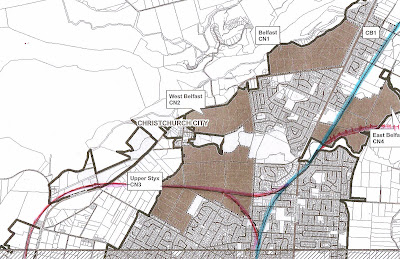
What a brilliant opportunity this presents to "build in" a bus rapid transit system before the street pattern itself is built. This might retain bus routes as already planned for Prestons and East Belfast but factor in a small in a couple of enclosed station hubs for direct busway services to the city, ditto along the pre-built busway routes. Services would travel under QEII drive and be ramped over Cranford Street, curve around the floodplain and join onto Rutland Street at a new elongated Rutland Reserve. Buses would then pass straight through a greatly redesigned area between Rutland Street and the top of Caledonia Road (in pat using land presently in Council Housing and the old Edgeware Pool site), running down Caledonia Road to curve round into Durham St North and straight down into the city, on all time bus lanes and traffic light signal priority. All in all, with prepaid loading a journey of as little as 12 minutes by BRT, currently taking 20-35 minutes or more in peak hour congestion. [a link to a Google map version is available here]

A guided busway - a low key technology punching way above its weight, less intrusive and more at natural ease with the environment than many rail options. Photo WikiMedia Commons
I see possibility for three, in parts grade-separated (segregated roading) bus rapid corridors, from the Grimseys Road corridor [as advocated by this blogster for many years] ; the Highfield Corridor; and the Prestons area.
All could intersect with and be linked to a east-west Prestons Road axis, re-developed as a six lane boulevard running from Northshore and Parklands-Burwood to the Airport - almost a straight line (coming straight across Main North Road at Redwood after purchase and removal of some properties in the Barnes Street area), running through proposed new housing areas in West Styx and industrial areas close to the airport - and then down into the Hornby area via Basham and Islington and onto Rolleston.
A key aspect would be the centre two lanes could be curbed off (mostly) for a bus rapid transit system running along the median strip, and getting a green light every time, irrespective of congestion delays on the adjoing road corridor - Rolleston to Burwood, "the Great Western".
The direct links into the central city - less than 12 minutes from Grimseys, Highfield, and Prestons? (and no time wasted finding and paying for a car park) - I believe will be a major factor in commercial and social survival of the city centre.
It seems to me that there is no way Hills Road, Cranford Street, Papanui Road etc could handle what probably amounts to a potential doubling or tripling of cars heading into the city from the north, especially at peak hours - even if CBD car parking space will be two a penny after the massive demolition of hundreds of buildings is finished.
The greater pulling power of modern diesel, CNG, hybrid or electric engines - such as this bi-artic
BRT bus in Bogota - makes rails larger irrelevant, clear run corridors can also offer access for multiple routes to feed quickly across cities or into the very centre of cities
Without a bus rapid transport option (as per video, linked below) faced with congestion and tedious traffic queues new northern residents are far more likely to refocus all work and play activities in new areas to the north further cutting off blood supply to the city centre.
If the city centre is to fight for its survival DIRECT FAST links from outer suburbs - by-passing congested mall areas already well served by conventional bus systems - could be a big feature of the strategy.
This You Tube video, via Tree Hugger, focuses on the essence of Bus Rapid Transit
In the last local body election we had Jim Anderton, Jo Kane and others talking about bus rapid transit - admittedly a first for this out of touch with trends city - as if it was just some sort of vaguely better version of the current bus lanes. These are a rather limited in scope bus lane system, on street painted lanes - except at the most congested points - and without traffic light priority or queue jumper lanes at most intersections, including intersections used by multiple buses per hour!
BRT station in Jakarta with platform level loading. Blending rail and bus advantages in one technology
In contrast a proper Bus Rapid Transit system offering very fast access could transform the northern suburbs with minimal need for park and ride lots and associated local area traffic traffic intensity that is usually required with rail solutions. In a busway system, as well as a branded 20/7 all stops-style frequent services, in peak hours various other routes could pick up in quieter suburban streets before feeding onto the busway corridors for a virtually non-stop blat into town.

The simplicity of a segregated corridor, in this case guided busway in Kesgrave UK (Wikimedia Commons)
Three busways into the city and one across town (build across several years of course) could offer over 45 kilometres of free run bus corridor, including cross town and downtown, for probably less than the infrastructure cost it would take to build a single 10km light rail line (based on overseas per kilometre light rail costs). Judging by the previous Mayor's comments about light rail on Papanui Road, or to the University, it would be a line doubt replicating the busiest bus routes in town to no significant advantage, instead of tying outer areas to the city centre as Bus Rapid Transit could do

Just desire to say your article is as surprising. The clarity in your post is simply excellent and i could assume you’re an expert on this subject. driving school belfast
ReplyDelete