Time-Traveller Rabbit Rambles in Rutland Park, 2030
When I was a young teenager starting to spread my wings - I spent several bits of time in the Hutt Valley and Wellington, usually with two or three other 14 or 15 year old boys. We would travel from our country town to the exciting metropolis, for a day or overnight, granted brief trial independence on the condition we stuck together and didn't talk to suspicious male strangers, and rung home now and then if we were several nights away. We stayed in youth hostels and lived on baked beans and meat pies! Some part of that time was always spent "riding the rails" on those most exotic of all vehicles, the Wellington's electric rail units. It was as if some part of New York had been transferred into NZ, the doors all opening simultaneously, the electric whirr of acceleration, the rush and roar of a train passing in the opposite direction, the sudden change of pitch in the clackety clack as the units crossed and re-crossed the Hutt River, the grumpy guard in his crumpled uniform shouting "All tickets from Naenae!"
Along with much other exotica, for small town boys (in an era when probably not one in 20 kids and then mainly only the rich ones travelled overseas) was the stream of place names. Sometimes the guard shouted the name out, "Next stop Taita" - sometimes the smaller stations just flashed by, the name had to be read at lightning speed. "Waterloo" "Wingate" "Woburn" all were as romantic sounding to me as some remote Pacific Islands.
My favourite was "Manor Park" - it always sounded so grand, so stately! In reality it was just a very small pocket of ho hum houses huddled inside a small pocket of land trapped between the Western Hutt Road and rail line and the curve of the Hutt River...I suspect the origins of the name possibly had more to do with a post-war developer (or perhaps the builders of the golf course there) talking up the real estate values.
Adding the word "Park" as I discovered in more cynical adulthood has long been a suspect title in the world of urban development. Christchurch's first electrified tram route to eastern areas of St Albans, about 100 years ago, went by the route name "Edgeware" - the longest intersecting road, of this area being Edgeware Road. North of this the locals called the area "the swamp" - very spongy, flood prone, market gardens that in the same period were being drained drained and converted to new subdivisions. Adding a park, literally, and calling it St Albans Park gave license to change the name of the area and the tram route to "St Albans Park". Which is good because Christchurch is flat and amorphous without many clear boundaries between some areas and it helps to have definite names for the east or west, north or south of some of the larger districts. such as St Albans. It needed a more definitive, separate name.
Just as I once travelled through the Hutt Valley on rail, hissing momentarily to a halt and seeing the distinctive large NZR platform sign "Manor Park" recently I have been travelling through the central St Albans area on the busway system. It is very evocative of those youthful trips that bring back memories of mad repetitive silly humour of boys of that age, those rail trips through the Hutt Valley of the early 1960s. Of course it is 2030 this year, I am retired, too old to get my ears in a flap, it is inevitable I'll spend a lot of time mooning on about the past. But modern bus technology - the longer articulated buses with computerised stabilisers, hybrid engines quieter than a small truck, continuous variable transmission (accelerates and decelerates with no obvious gear change) and the vibration free, lurch free quality of the busway roading, means that a rapid bus journey nowadays is little different in feel from a journey on a rail unit, or tram, indeed smoother for that matter. And the way they have stations with proper entry level platforms, sometimes enclosed shelters, it feels like those rail journeys of old.
Travelling up Rutland Street we pass Rugby Park - well it used to be Rugby Park, recently they named it after that famous rugby player, you know whatshisname...damn can't remember!! There is a bus station there but I don't catch the name on the sign nor can I see the electric station name sign the front of the bus, nor here the automated voice "Next stop..." Well if I don't wear my glasses, or hearing aid.... Still the way the rugby authorities and the council worked to incorporate the beautiful big trees into the design, is impressive. They also have a big platform for rugby match crowds, now so many catch public transport.
The bus slides effortlessly away from the platform to cross Innes Road (always green for buses) and next stop is at the top of Rutland Street near Paparoa Street,. Aaah, that station name "Rutland Park", now I realise that's what got me thinking of Manor Park - all those long ago moments of youthful awakening to the wider world around (ok so it was the grotty old Hutt Valley - it was still young and fresh in my eyes!!). Unlike the name St Albans Park which never really stuck the name Rutland Park "took" - it gave identity to that area between St Albans and Papanui and part of that is the beauty of the actual park itself. This was always designed more as a minature botanical gardens than just a wide open space, though that there is too. It was primary built for the quadruple purposes of flood control, busway embankment, school access and "older people" open space. It was fairly clear as soon as the busway was on the drawing board that any housing area near a busway was going to go up in value, here in Christchurch, as overseas, because of the intensification of the area to take advantage of the easy frequent access to the city or Northlands. Up towards Northlands and down towards Edgeware, Caledonia Road etc of course that is high rise apartments, around Rutland Park this is mainly a proliferation of older persons housing and retirement complexes. Building the park - basically extending the Rutland Reserve northwards alongside the school there - connected up Grassmere Street and Rutland Street in a "no car access" - pedestrian, cyclist, friendly way.
It is a very direct route to the city and for cylists a lot less traffic to contend with, the whole route length into town. The swales and winding creek and water features created down the middle of Rutland Park offered a broad meander pathway of gentle slopes and rises and the occasional bridge, very attractive (and more than a few subtle handholds and plenty of seats to rest here and there and toilets at each end of the park- sigh for the troubles of aging!) all particularly orientated for the larger than usual number of older walkers that use this park. Of course there are also some beautiful shrubs and rose garden areas, as well as native bush enclaves. Near the eastern edge, towards the old Paparoa School there is a motorway - no, I joke - but it is a sort of the equivalent of a motorway, a bike motorway, a tarsealed cycle way so broad that it has room for slower, younger children idling their way to school, and on the right the de facto "commuter" lane for adult cylists travelling faster to and from work. Hundreds of people bike down this route everyday, being off the busier main roads. The cycleway area being open and wide away from the more treed and bushed meander path it also is a "safe about strangers" area for children walking or riding to school - hardly a moment without a cyclist or several passing. There is no easy place near this cycleway for ill intent to hide. The cycleway even has a a "downpour shelter" and fuel station - a set of drinking fountains including one easy to use whilst stopping on a cycle - a halfway point between the city and Northcote or Redwood for many cycle commuter.
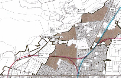
Behind all this is a contoured treed embankment with bedstead fencing - this is the Northern and Belfast busways, curving back to rejoin Grassmere Street (the Northlands busway) or the Belfast Busway branching off to the north, across the floodplain towards Belfast (passing under Cranford Street and under QEII Drive) . The great thing about building infrastructure from scratch was that they were able to create a very attractive busway of minimum intrusion, quite separate from pedestrians or neighbouring houses, barely visible as it skims behind the trees at 70km per hour. And of course at peak hours extra buses coming from other points in the north not served by either of the busway routes, also use this quick access to and from the city in rush hours - non-stop I think it only takes them 7 minutes from Northlands to the first one-way cross street near the Casino, compared to the conventional bus services for those travelling down Papanui Road which take about 14 minutes.
Compared to building a railway line or light rail corridor this busway was fairly cheap, but with its park on one side and open paddocks and underpasses, its away from the traffic feeling, it feels very classy. Unlike trams which date and get tired looking are hugely expensive to replace these buses are replaced with an entirely new fleet every ten years, latest technology included, and still less than a fifth the prrice of the cheapest smallest tram! Also I remember in that period Auckland, about 15 years ago, was buying up and demolishing literally hundreds of houses and businesses to bring rapid transit to Manakau; amazingly in Christchurch we needed to purchase less properties than the average Shopping Mall carpark expansion - for the whole city and seven rapid transit routes!
Thank God we got political leadership dedicated to serving the whole city in a balanced way, before the fuel, power and water crisis, rendered using cars for commuting to work a pointless and silly waste of money. A team that had the nous to identify and take possession of all the key points that would make rapid transit possible, before they were compromised and built over. Made it a much nicer place too - I remember how ugly those crowded streets, bumper to bumper queues, vast car parking areas had made the city - nowadays that car traffic is lighter in the rush hour at least kids can cycle to school again. It is so important that children have the space to slowly grow wings, bit by by bit moving away from home. It is one of the many spiritual damages an over-dose of car addiction was killing in our society. Yeah going for holidays to Australia with the parents may involve traveling further, seeing more, but it is the act of leaving parents behind, by bicycle, bus or train, discovering the world on one's own terms that really counts.
I wonder if some kids, barely teenagers, perhaps up from Rakaia or down from Cheviot, buzzing up and down the busways, eating chips and giggling and hooning about, still feel even just a small tang of the exotique when they see these new names like "Rutland Park" and experience the energy of a vibrant city, the same sense of a world to discover myself and my crazy mates felt.
Zzzzz - oops I must have drifted off again.
Along with much other exotica, for small town boys (in an era when probably not one in 20 kids and then mainly only the rich ones travelled overseas) was the stream of place names. Sometimes the guard shouted the name out, "Next stop Taita" - sometimes the smaller stations just flashed by, the name had to be read at lightning speed. "Waterloo" "Wingate" "Woburn" all were as romantic sounding to me as some remote Pacific Islands.
My favourite was "Manor Park" - it always sounded so grand, so stately! In reality it was just a very small pocket of ho hum houses huddled inside a small pocket of land trapped between the Western Hutt Road and rail line and the curve of the Hutt River...I suspect the origins of the name possibly had more to do with a post-war developer (or perhaps the builders of the golf course there) talking up the real estate values.
Adding the word "Park" as I discovered in more cynical adulthood has long been a suspect title in the world of urban development. Christchurch's first electrified tram route to eastern areas of St Albans, about 100 years ago, went by the route name "Edgeware" - the longest intersecting road, of this area being Edgeware Road. North of this the locals called the area "the swamp" - very spongy, flood prone, market gardens that in the same period were being drained drained and converted to new subdivisions. Adding a park, literally, and calling it St Albans Park gave license to change the name of the area and the tram route to "St Albans Park". Which is good because Christchurch is flat and amorphous without many clear boundaries between some areas and it helps to have definite names for the east or west, north or south of some of the larger districts. such as St Albans. It needed a more definitive, separate name.
Just as I once travelled through the Hutt Valley on rail, hissing momentarily to a halt and seeing the distinctive large NZR platform sign "Manor Park" recently I have been travelling through the central St Albans area on the busway system. It is very evocative of those youthful trips that bring back memories of mad repetitive silly humour of boys of that age, those rail trips through the Hutt Valley of the early 1960s. Of course it is 2030 this year, I am retired, too old to get my ears in a flap, it is inevitable I'll spend a lot of time mooning on about the past. But modern bus technology - the longer articulated buses with computerised stabilisers, hybrid engines quieter than a small truck, continuous variable transmission (accelerates and decelerates with no obvious gear change) and the vibration free, lurch free quality of the busway roading, means that a rapid bus journey nowadays is little different in feel from a journey on a rail unit, or tram, indeed smoother for that matter. And the way they have stations with proper entry level platforms, sometimes enclosed shelters, it feels like those rail journeys of old.
Travelling up Rutland Street we pass Rugby Park - well it used to be Rugby Park, recently they named it after that famous rugby player, you know whatshisname...damn can't remember!! There is a bus station there but I don't catch the name on the sign nor can I see the electric station name sign the front of the bus, nor here the automated voice "Next stop..." Well if I don't wear my glasses, or hearing aid.... Still the way the rugby authorities and the council worked to incorporate the beautiful big trees into the design, is impressive. They also have a big platform for rugby match crowds, now so many catch public transport.
The bus slides effortlessly away from the platform to cross Innes Road (always green for buses) and next stop is at the top of Rutland Street near Paparoa Street,. Aaah, that station name "Rutland Park", now I realise that's what got me thinking of Manor Park - all those long ago moments of youthful awakening to the wider world around (ok so it was the grotty old Hutt Valley - it was still young and fresh in my eyes!!). Unlike the name St Albans Park which never really stuck the name Rutland Park "took" - it gave identity to that area between St Albans and Papanui and part of that is the beauty of the actual park itself. This was always designed more as a minature botanical gardens than just a wide open space, though that there is too. It was primary built for the quadruple purposes of flood control, busway embankment, school access and "older people" open space. It was fairly clear as soon as the busway was on the drawing board that any housing area near a busway was going to go up in value, here in Christchurch, as overseas, because of the intensification of the area to take advantage of the easy frequent access to the city or Northlands. Up towards Northlands and down towards Edgeware, Caledonia Road etc of course that is high rise apartments, around Rutland Park this is mainly a proliferation of older persons housing and retirement complexes. Building the park - basically extending the Rutland Reserve northwards alongside the school there - connected up Grassmere Street and Rutland Street in a "no car access" - pedestrian, cyclist, friendly way.
It is a very direct route to the city and for cylists a lot less traffic to contend with, the whole route length into town. The swales and winding creek and water features created down the middle of Rutland Park offered a broad meander pathway of gentle slopes and rises and the occasional bridge, very attractive (and more than a few subtle handholds and plenty of seats to rest here and there and toilets at each end of the park- sigh for the troubles of aging!) all particularly orientated for the larger than usual number of older walkers that use this park. Of course there are also some beautiful shrubs and rose garden areas, as well as native bush enclaves. Near the eastern edge, towards the old Paparoa School there is a motorway - no, I joke - but it is a sort of the equivalent of a motorway, a bike motorway, a tarsealed cycle way so broad that it has room for slower, younger children idling their way to school, and on the right the de facto "commuter" lane for adult cylists travelling faster to and from work. Hundreds of people bike down this route everyday, being off the busier main roads. The cycleway area being open and wide away from the more treed and bushed meander path it also is a "safe about strangers" area for children walking or riding to school - hardly a moment without a cyclist or several passing. There is no easy place near this cycleway for ill intent to hide. The cycleway even has a a "downpour shelter" and fuel station - a set of drinking fountains including one easy to use whilst stopping on a cycle - a halfway point between the city and Northcote or Redwood for many cycle commuter.
Behind all this is a contoured treed embankment with bedstead fencing - this is the Northern and Belfast busways, curving back to rejoin Grassmere Street (the Northlands busway) or the Belfast Busway branching off to the north, across the floodplain towards Belfast (passing under Cranford Street and under QEII Drive) . The great thing about building infrastructure from scratch was that they were able to create a very attractive busway of minimum intrusion, quite separate from pedestrians or neighbouring houses, barely visible as it skims behind the trees at 70km per hour. And of course at peak hours extra buses coming from other points in the north not served by either of the busway routes, also use this quick access to and from the city in rush hours - non-stop I think it only takes them 7 minutes from Northlands to the first one-way cross street near the Casino, compared to the conventional bus services for those travelling down Papanui Road which take about 14 minutes.
Compared to building a railway line or light rail corridor this busway was fairly cheap, but with its park on one side and open paddocks and underpasses, its away from the traffic feeling, it feels very classy. Unlike trams which date and get tired looking are hugely expensive to replace these buses are replaced with an entirely new fleet every ten years, latest technology included, and still less than a fifth the prrice of the cheapest smallest tram! Also I remember in that period Auckland, about 15 years ago, was buying up and demolishing literally hundreds of houses and businesses to bring rapid transit to Manakau; amazingly in Christchurch we needed to purchase less properties than the average Shopping Mall carpark expansion - for the whole city and seven rapid transit routes!
Thank God we got political leadership dedicated to serving the whole city in a balanced way, before the fuel, power and water crisis, rendered using cars for commuting to work a pointless and silly waste of money. A team that had the nous to identify and take possession of all the key points that would make rapid transit possible, before they were compromised and built over. Made it a much nicer place too - I remember how ugly those crowded streets, bumper to bumper queues, vast car parking areas had made the city - nowadays that car traffic is lighter in the rush hour at least kids can cycle to school again. It is so important that children have the space to slowly grow wings, bit by by bit moving away from home. It is one of the many spiritual damages an over-dose of car addiction was killing in our society. Yeah going for holidays to Australia with the parents may involve traveling further, seeing more, but it is the act of leaving parents behind, by bicycle, bus or train, discovering the world on one's own terms that really counts.
I wonder if some kids, barely teenagers, perhaps up from Rakaia or down from Cheviot, buzzing up and down the busways, eating chips and giggling and hooning about, still feel even just a small tang of the exotique when they see these new names like "Rutland Park" and experience the energy of a vibrant city, the same sense of a world to discover myself and my crazy mates felt.
Zzzzz - oops I must have drifted off again.

Comments
Post a Comment