Is NZ Transport Agency going about things completely the wrong way?

Roadside berm approaching Memorial Avenue on Russley Road ready for conversion to four lanes and a planned over-bridge on this road over Memorial Avenue.
The government arm responsible for planning transport infrastructure in New Zealand - several name changes down the track called New Zealand Transport Agency - appears to be putting the economic future of Christchurch at risk.
NZTA is planning to build an over-bridge to replace the current roundabout at the intersection of Russley Road and Memorial Avenue. The pamphlet they produced to explain this states;


The existing two-lane section of Russley Road between Yaldhurst Road and Wairakei Road is proposed to be upgraded to a four-lane median separated road. In this proposal the Russley Road/Memorial Avenue roundabout will be upgraded to become a grade separated interchange with Russley Road going over Memorial Avenue.
Four laning Russley Road between Yaldhurst Road and Wairakei Road and upgrading theRussley Road/Memorial Avenue intersection will provide improved and more predictable travel times for vehicles using the Western Corridor between Hornby and Belfast and for vehicles travelling to and from the airport.
The SH1 (Russley Road) Wairakei Road to Yaldhurst Road Four Laning is a key project in the government's roads of national significance programme, announced in 2009.
As with National's simplistic band-standing and flag-waving about so called RONs (Roads of National Significance) there doesn't seem a great deal of depth of thought going into this**.
Good infrastructure is rarely about the grand gesture so beloved by politicians, it is about dozens of mundane details into the right combination.
In this case of the building the over-bridge Russley Road over Memorial could costs the future city or subsequent Governments tens of millions of dollars.
Is Government or Council acting to protect long term city interests?
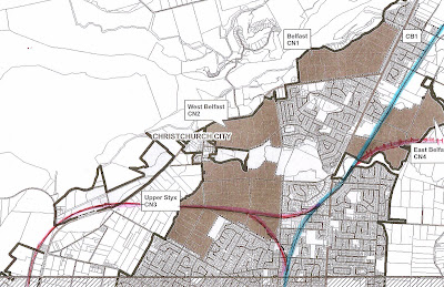
Christchurch currently has a single narrow rail corridor coming into the city from the north, from Styx Bridge to Addington a corridor intersected by few passing loops and multiple level crossings - a form of grade level inter-action that is essentially obsolete technology in modern city conditions (and was in the Hutt Valley back in 1953!). This situation is aggravated by the decision back about ten years ago to build a new Blenheim road over-bridge directly off the end of Moorhouse Avenue in such a manner it can never be possible for future trains from the north to turn directly eastwards towards the city centre and towards Lyttelton.
The Styx Bridge-Addington rail is a corridor also hemmed in by housing, much of it middle to upmarket housing (in Christchurch proximity to railways or airports is considered a status symbol!!) and the city's most effective and attractive cycle and pedestrian "highway".

Northern rail line into Christchurch crosses Wairakei Road - on the right the "motorway" of quality cycle, skate and pedestrian tracks - could this line be double tracked now without destroying this or creating huge local resistance!
Attempted conversion back to double track width would be almost guaranteed political suicide for any Christchurch Council that tried!
By itself this section of line connects few dots for commuters and would struggle to maintain both freight and a constant (two to six trains per hour in either direction) commuter service in good conditions - let alone when freight or passenger delays, shunting mishaps and minor derailments, locomotive breakdowns, and level crossing crashes, suicides and fatalities to pedestrians block the one and only access to city and Port. If it is to be the tail end of the "Auckland-Christchurch Rail Corridor" (the heavy freight backbone of urban New Zealand) it is a pathetically feeble and emaciated tail! And it has almost no elasticity to protect the future
Most people older than about forty years begin to realise that absolutely nothing in life is predictable. The relatively sparse freight traffic on the northern line today, especially compared to the west coast line, could change any-time.
Some possible examples - massive dairyfication in North Canterbury requiring coal power from west/container exports via rail ; a new species of fast growing hardwood developed replacing pine forests in Culverden and a creating a huge export industry through Lyttelton (or just a huge demand and very high prices for any wood everywhere in the southern hemisphere); collapse of the wine industry in the Murray Basin due to global warming water loss, creating a huge trans-tasman demand for Marlborough and North Canterbury wines to ship through Lyttelton; pressure to grow a much bigger city north of the Waimak; changes in the world economy and a change back to production in home countries with Christchurch again becoming a major manufacturing centre supplying the much more heavily populated north.
Or the simplest scenario of all - extreme escalation of oil prices due to peak oil demand greater than supply/because of over-estimation of world reserves causing massive rise in commuting costs by private car for those living north of the Waimakariri River forcing demand for commuter rail.........
Just a few of so many possibilities that would make it absolutely stupid for a city to strangle itself by failing to protect or create sufficient provision for multiple freight and passenger rail movements, even if the provision looks 30 or 50 years to the future when population may be a million plus.
Stupid it might be but this appears to the legacy likely of Stephen Joyce and Jerry Brownlee as Ministers of Transport if Christchurch does not look to putting in place a long term future-proof plan for the northern rail access. (we won't mention the lack of Council vision on this issue to date!)
The proposed alignment of Russley Road over Memorial Avenue, rather than Memorial over Russley will preclude the opportunity to carry this same over-bridge right across a railway line built in the broad sliver of land between Russley Road and planned (and existing) commercial and industrial land on the west side of Russley Road.
Even without shifting Russley Road a few metres over towards the city (allowing very attractive ramping and noise control embankments or planting such as in the photo below of Aidenfield Road ) this land area as shown at the top of this posting would easily supply sufficient land space to allow rail including double tracking or passing loops for a rail corridor.

Land humps in a flat city! Recently constructed along Aidenfield Drive - these appear to be made from land-scraping subdivision sites. But could similar and other embankments be built on the city side of a suggested railway corridor past the airport and through Upper Styx using earthquake rubble railed to site, as a base? Well planned rail need not be industrial-strength ugly!
Current plans by NZ Transport Agency will block any easy future attempt to build a decent rail access corridor north of Christchurch via the currently open land and airport route - as below.
This is the only alternate route into Christchurch still mostly in open country, and yet engaging enough with large enough sector new North, North-western and western residential and industrial areas as well as the Airport., Hornby and Addington sports and events zone, before entering the city centre. Unlike light rail proposals it has massive room for "transit orientated development" and (though feeder buses are far preferable) the sort of massive car parks often used by rail and light rail elsewhere in NZ and overseas to boost patronage of this mode*. Traffic flow to such car-parks (unlike those that would be needed for light rail in Ilam) would be counter-flow to city bound traffic requiring little extra roading and making more effective use of roads (though to repeat, effective feeder buses and a cycleway network are far, far better!!!)
In contrast later alternatives for a new rail access from the north would massive demolitions of existing housing areas or (if via Airport) per se require expensive cut and cover trenching areas around the airport and under Memorial Avenue near the planned Russley Road over-bridge.
Lack of foresight could remove the simple elegance of utilising a Memorial Avenue aligned over-bridge, This allows trains, electric shuttle buses (doing a constant loop around the airport terminals and work zones) and other suburban and long distance buses and taxis and private cars easy "under the over- bridge" access, such as a spaghetti junction off ramp, to access this key transport hub.
The sophisticated first face of a little city with its act together - the point where the tourist goes wow!

BluPure offers consumers pure, refreshing water, with all of the harmful contaminants removed. And the best part is that it can be used with any tap water source, saving money and the planet. BluPure is going to revolutionize the water industry, finally giving people everywhere the healthy water they deserve without having to pollute the world in the process.
ReplyDeleteThe item senses brilliant to learn to read like beneficial in addition to one of a kind articles or blog posts with your internet websites. Packers and Movers Hyderabad
ReplyDelete