City to Burwood, Prestons - fifteen minutes by busway?
"What is needed are public transport systems - additional to those already operating - which in effect "leap across" the inner suburbs [or in reality "cut through them, rarely stopping] and link the outer areas to the central city with ease of access and short attractive journey times".


Let's take a journey on the busway suggested above
...first step recall USA expression "Think rail- build bus" - this is a level of commitment to public transport similar to that normally only given rail

Mercedes CapaCity Buses - carrying up to 193 passengers - on segregated busway lanes in Istanbul. With recent extended vehicle length for trucks is it possible than vehicles of this size and quality could one day service specialised busway corridors in Christchurch ? (photo source wowTurkey.com) Click on any image to enlarge
The dweaded wabbit has been flushed out of hiding by the need to float a few new seeds of thought into the the public consultation on the Prestons development. Prestons is a huge housing development planned by a consortium of Ngai Tahu (the South Island's largest Company), supermarket chain Foodstuffs and Singapore linked developer CDL Land New Zealand. If permitted it will eventually cover an area bigger than Hagley Park and house 6000 people. I have had several looks at the plans, and a tiny portion of the vast reading matter (literally volumes of info!). On the basis of a nosey rabbit scan it seems impressively well thought through and well suited to the Christchurch of today - mainly the classic suburban homes, but also greater housing concentration around the core areas, which also include school areas and shopping facilities etc. Also what looks like good bike and pedestrian pathways and easy access to central core bus routes already identified.
The ironic thing is that it falls outside the designated areas of the Urban Development Strategy which is designed to try to stop random spread of the city (or Rolleston and Rangiora) and concentrate more population growth in the centre. This said the Preston scheme hangs together well, is substantial and long term in nature, the money and expertise appears to be there and ready to go, and the big players are definitely not in the fly-by-night class, and are very committed. "Prestons" may indeed have a strong case for rezoning, not least on the the basis all giant masterplans immediately get overthrown by a compelling contradiction (Murphy's Law of Planning).
Space is our greatest wealth in New Zealand and even though I tend to be much more an urbanite than suburbanite, I respect there is and always will be great value for families in having a detached house, a fenced yard, a bit of land to swing a cat (yeah right rabbits harbour malicious thoughts towards cats!). I'd much rather see a sophisticated transport public system sustaining a spread out life-style, than every one having to huddle in those horrible Auckland style minimalist (dare I say it) rabbit hutch size flats. As I say space - in the street, in the mountains, in the room size, in the house size, in our sections - makes us very wealthy as a country. "We got plenty of nothing" so let's not be in a rush to throw it way!! The actual amount of land used for urban areas in NZ is really fairly small, despite stereotypes of urban sprawl devouring all. The main consequence is congestion when lots of folks from perimeter areas try to simultaneously drive into the central city areas - logically the closer one gets to the centre the more crowded and gridlock vulnerable streets become, the less options to widen or change them. What is needed is public transport systems - additional to those already operating - which in effect "leap across" the inner suburbs [or in reality "cut through them, rarely stopping ] and link the outer areas to the central city with ease of access and short attractive journey times.
In Christchurch , which does not have elongated narrow valleys or coastal corridors or estaurine traffic choke-points (let alone the larger, high density population or big local and national taxpayer base) that make possible and foster rail usage I suggest busways - or "Bus Rapid Transit corridors" offer better option.
In Christchurch , which does not have elongated narrow valleys or coastal corridors or estaurine traffic choke-points (let alone the larger, high density population or big local and national taxpayer base) that make possible and foster rail usage I suggest busways - or "Bus Rapid Transit corridors" offer better option.
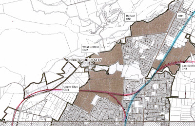
I have been interested in busways for most of the last decade and have had plenty of time to think about options in Christchurch. These are relatively limited in every area of town, without massive social disruption and huge costs. Generally judicious linking of secondary (uncongested) arterial roads with some bus only infrastructure could produce very fast corridors (the buses don't actually speed - they are fast because they are never held up by traffic and their routes are short-cuts). Wellington has 210,000 people living up the Kapiti Coast and Hutt Valley corridors served by commuter rail - this pattern bears no relationship to Christchurch in any depth analysis. Most - two thirds - of the greater Christchurch "outermost 210,000 residents" live not in Rangiora or Rolleston but in areas contingent with the core city areas, showing in the Mickey Mouse ear pattern in the rough map below, and this ratio will not change. Identifying our city's peripheral population is based on drawing a circle at approximately 5km radius from the city centre and then looking at the major residential or activity areas built, or planned, out beyond that circle; one of these is the proposed Prestons suburb, and also across Burwood, Tumara Park, Parklands and North Beach, North Shore.
It is my belief that each of these outer areas should be able to reach the city in peak-hours in less than 25 minutes (cuurently typically 35-40 minutes) by bus rapid transit corridors - fifteen minutes picking up looping around the outer residential area then feeding onto the busway trunk corridor which has various technologies to give the bus uninterrupted flow - ten minutes to the city non-stop [or key stop only] from the point where the route crosses that circle; in the case of the eastern mouse ear that is Breezes Road or in the north east, where New Brighton Road encounters the Avon River.
Rough schemata of outer areas needing fast direct public transport connection to the centre. Red lines indicate possible busways needing significant infrastructure, green lines bus routes enhanced with added lanes at lights or traffic light priority. If you look closely there are some orange lines, indicative only, branching out from each busway trunk route - peak hour express routes using the busway trunks. Alternate to the Marshlands busway indicated above is the suggestion below.
Busways (in USA bus rapid transit corridors) are based on giving buses much the same infrastructure base and clear run advantage of trains. In particular this is achieved by using a mix of bus lanes on roads shared with other traffic (some times curbed against other vehicles using them) and queue jumper lanes and/or GPS activated priority at traffic lights; also typically using completely segregated bus corridors built on shoulder lanes of motorways, or utilising former railway lines, or cut through from one area or set of roads to another by purchase and removal of certain properties. Trenches or subways or bus tunnels can be used to keep public transport separate from other traffic or even (as mentioned in a recent post) carrying bus lanes across the top of buildings! Typically peak hour buses are express and virtually don't stop outside their pick up zone or stop only at key stops, which have enclosed waiting areas, platforms and real time signage. At busier stations passengers typically pay their fare at an automated turnstile to get onto ther loading zone, computerised technology insuring multiple bus doors line up at these points, so passengers can just enter, any door (at platform level) and minimal time is spent loading passengers. In some busway systems guide wheels built onto the side of steering wheels allow buses to use concrete (and grass!) guided busways at much higher speeds and very smooth running surface. Of course, unlike trains, even guided buses can enter or leave busways at any point, in effect being like carriages sharing a central trunk route but breaking off top service immediate neighbourhoods. Given the land needed for car parks for those transferring to rail - over 4000 rail-linked car parks in greater Wellington - this is not only far more convenient for passengers but also significantly lowers commuter impact on quiet suburban neighbourhoods and reduces overall infrastructure costs.
Below in a rough map I illustrate a potential Eastern and North-eastern busway pattern based on the bus rapid transit concepts now being successfully adopted worldwide (though "successfully ignored" for over 15 years in Christchurch).
Note; June 2011; The map below predates the nine months of earthquakes that destroyed much land in the area described. Whether this would make building the proposed alignment easier or more difficult; or more vital or irrelevant, is hard to forecast. Prestons itself seems more likely to go ahead.
Let's take a journey on the busway suggested above
...first step recall USA expression "Think rail- build bus" - this is a level of commitment to public transport similar to that normally only given rail
From the new Bus Exchange up Colombo St and through the Square but exiting via Worcester Street... crossing Manchester Street...
Worcester east of Manchester is now primarily a parking zone and it would become more so but with an attractive platformed bus station in the centre of the road ...bus loads pre-paid passengers
..bus moves off and descends ramp that takes it into a tunnel under the western road of Latimer Square and under the square itself, in a trench or actual tunnel cut in the wide gap between trees where the road used to be...perhaps it will be a full tunnel or perhaps it will be a securely attractively meshed trench with wild roses growing around it ... there is enormous scope for something very special architectecurally, such as an underlit water-feature built on the busway tunnel roof - bus continues under Madras Street ...or even under Barbadoes St too...to emerge back up on Worcester Street
......continues down Worcester to Fitzgerald with traffic light priority according to a computerised formula - will hold green light or start green phase slightly earlier but not entirely disrupt Fitzgerald Ave flow pattern (giving 75% priority)
.....along Worcester Street, light priority means it never has to stop crossing Stanmore Road. With most through traffic now channelled on Cashel and Gloucester Streets, Worcester more than ever becomes a bus and cycle way, at Stanmore Road another attractive centre road small platformed bus station...
....at Linwood Avenue another station then the bus again travels into an underpass (there is a segregated lane for bikes and pedestrians) and emerges on the leg of Worcester Street east of Linwood Avenue
...continuing east along Worcester St (east) the bus veers left several hundred yards before Worcester St itself encounters Woodham Road, here the bus enters a wide green boulevard wiith landscaping, cycleways,pedestrian where several houses have been purchased and demolished to allow a direct busway alignment from Worcester Street - room for a Dallington rapid bus station - before crossing Woodham Road onto Ngarimu Street, with bus activated always green lights...(journey time from city approx 6 minutes).
..at the Woodham/Ngarimu bus lights express buses to New Brighton and to South Shore leave the busway turning right into Woodham Road) to travel to Pages Rd having avoided most congestion associated with the inner city, Linwood Ave and Eastgate, and saving approximately 7or 8 minutes in total journey time
..crossing Woodham Road the bus continues up Ngarimu Street,
....with express busway services to Wainoni and North Shore via QEII turning right along Durnanon and emerging on Wainoni Road - having avoided most congestion associated with the inner city, Linwood Ave and Eastgate, and saving approximately 7or 8 minutes - perhaps also having a queue jumper lane and traffic light priority at a widened Wainoni Road and Breezes Road intersection
....Services to Burwood and Prestons traveling along Ngarimu Street then cross a purpose built bridge about 500 metres south of the Dallington Bridge - this bridge has lanes only for buses [single lane-peak hour demand urgency only flows one way] and cycles and pedestrians. Perhaps it curves as it crosses, perhaps the current steel footbridge in this area is relocated and extended further seaward to link New Brighton Road (and the busway) across to Avondale.
The busway corridor then travels along Locksley Terrace especially widened or re-structured by extending the grassed stop bank out across the road to include a semi-segregated full time enhanced surface 60kmh peak-hour direction bus lane beside the river with great views on the way to work. (contra peak buses just use road) .....until traffic light access (and bus priority) turning right onto New Brighton Road (journey time from city approx 10 minutes)... if unfamiliar with this area search for "Locksley Avenue" in Google Maps here, you can even get street level views).
.......along New Brighton Road about a kilometre then left into Burwood Road (traffic lights to assist city-bound bus access onto New Brighton Road) continues up Burwood Road to queue jumper lane at QEII Drive lights, peaks hours moves off 10 seconds ahead of other traffic, continues up Burwood Road to Hospital (journey time from city approx 15 minutes - current journey by bus takes 33 minutes ) and then to Tumara Park and Parklands, or to Prestons.
Of course not all buses would be express in this manner described. This is primarily a peak hour pattern for those travelling directly to the city or across the city , and therefore not needful of going through congested areas near malls, and not stopping from a certain point onwards. Conventional routes would continue to offer the city-via the mall-outer suburb pattern as now. On the busway corridors themselves a branded service (like the Metrostar) could offer a 7 day a week all stops service, stopping at some intermediate street- side stops, between the primary location platformed mini-stations, for those who wish to travel into the city and don't need to go via a mall. Even so a much faster journey.
I imagine such a busway as described here might cost several tens of millions, and still come in far cheaper than a comparable rail or light rail that could only travel to one terminus area as compared to six or seven express routes feeding into the busway above. I envision the busway along Worcester Street and right upto the point where it joins New Brighton Road not as some heavy industrial corridor but rather a "green river" - all car traffic beyond Stanmore Road along Worcester Street, Ngarimu St, and Locksley Terrace being much more "access to neighbourhood" orientated. Less through traffic, and apart from a flurry of buses on business days only at peak times, these streets would be less busy than most, and have a 15 or even 10 minute constant branded busway service. Every busway is a chance to enhance the area through which it passes! From another angle, each busway trunk route is also a tree root keeping the central city and outer suburbs connected, the city as a whole cohesive and alive.

At Pristine Maintenance, we urge all building owners NOT to ignore roofing problems that can easily result in substantial damage to the structure and its contents. Our expert technicians are ready to inspect your roof and provide you with a detailed assessment of its condition.
ReplyDelete