Wheels Missing on Highfield's Green Energy Claim

Project legit Graffitti on Grimseys Road QEII Drive cycle underpass
I was impressed to read earlier in the year that the large new subdivision to be built east of Redwood, called Highfield would be the first in the country where solar panels and solar (assisted) water heating would be the norm in every house.
According to The Press report retrieved here
"All 2200 homes in Christchurch's proposed Highfield subdivision will be fitted with solar-energy systems, making it New Zealand's biggest solar community. The systems, consisting of both photovoltaic and hot- water panels, would supply about a quarter of a typical home's energy needs, developer Maxim Projects says.
When the vast documentation that precedes all major new projects appeared in our local library (Proposed Plan Change 67 I think is the official title) I naturally thought what are the developers doing about public transport? The City Council has a minimal effort programme and Metro is on the funding cutback downgrade; so things are very gloomy but perhaps something innovative might be coming from these developers.
I thought this because I had been quite impressed reading - scanning (it's several volumes, many hundreds of pages) - the even larger folders supporting the Prestons development.
I liked the way they designed a bus route into the heart of the Prestons subdivision, serving the hub but also identified specific stops, showing where people could walk through green areas, parks or alleys to easily access streets further away in getting to and from bus stops.
The East Belfast subdivision (whatever its official new name is) did similar.
The land in the north of Christchurch - the farmland north of QEII Drive - is apparently stable and safe to build upon with suitable preparation but does suffer one problem, distance from major work zones and from the central city. This includes "distance" as in time waste and congestion queues as much as in actual kilometres.
Maybe I missed something, in my quick visit to those two vast volumes of City Plan Change 67 (the Highfield proposal), but solar energy aside the whole thing had the distinct smell of the 1980s or earlier - build a vast subdivision a long way from major employment and shopping zones, with nothing but a rudimentary bus service that will take 30-40 minutes (or longer with transfers) to get to the city and most workplaces through congested roads.
On the map of Highfield in the hefty Plan Change documents a few dotted lines show "possible bus route". What? Possible? Possible? You've got to be joking! What sort of planning and upgrading of public transport in Christchurch can such a flaky presentation as this represent?
The whole world is moving towards planned land use and public transport infrastructure as a tight package and here is an outlying suburb planned on a she'll be right basis, plonk a bus here basis. Indeed the "possible" route itself is quite circuitous, a necessity because the subdivision makes no attempt to create easy links between streets to facilitate fast easy bus routes that empower public transport as an option.
As I said the distinct smell of old technologies. These days are surely a time of a very high risk future, with oil production now appearing to have peaked, the world unable to pump out more than 75 mbpd for the last seven years despite massive growth in car ownership and fuel consumption from countries such as India, China and Russia. Oil price rises have hardly begun to rise yet but already people are cutting privately journeys significantly, as reflected in this survey last week in Auckland.
Presumably solving the post-earthquake housing shortage does not also include building in protection and mitigation for the expected disastrous effects - and much greater effects than the earthquakes because every part of the country/world will be suffering - likely from the effects from the climate change and oil price escalation. No where is it clear that the developers are (a) aware of this (b) working with local Government to address this at the very core of their project (c) that local government is itself in competent hands when it comes to public transport infrastructure planning.
The Appendix 10 to the Plan Change 67 (part of another huge volume) covers Transport and this includes Public Transport, of course. It also includes all the magical chants and incantations that we hear so often and that have now almost replaced actually strategic planning, concrete projects and making hard nosed decisions as a Council culture. The section has a whole section of tick boxes as to how well the project meets the City Council's various criteria.
At 26 pages this section is far too lengthy to fully enumerate in this short blog but here a few samples (Councilspeak in bold; developers response in normal type)
Transport Objective
An efficient , safe and sustainable transport system in the city which provides for ease of accessibility for people and goods
Assessment; consistent;The Plan change is not expected to generate any adverse effects on the transport system.
7.1.5 Policy; Minimising Adverse Effects
To encourage changes in the transport system towards sustainability
Assessment; consistent; The Transportation Assessment demonstrates that the
PLan Change is supportive of walking, cycling and public transport modes of travel.
and in the specific public transport section
M 1.3.10 Provide traffic management schemes that give priority to public passenger transport services over private motor vehicles (especially single occupancy vehicles) in areas of traffic congestion, particularly on high demand transport corridors.
Assessment; N/A
M 1.3.12 Develop an interconnected network of passenger transport services that provide frequent and convenient access to key employment, educational, shopping and recreational zones
Assessment; N/A
and much more of the same.
I am not assuming that private developers should be replace the role of long term forward the transport planners for the city but I do ask;
"What is the point of requesting compliance with all the fine words and proclaimed strategic goals if all a developer has to say is - "Yep a bus can run down this street or maybe that one, no probs mate".
If one of the largest subdivisions in the city has no more planning or strategy than a "possible" conventional and fairly convoluted bus route, in what sense is this any different from 1975 (or indeed 1935) in encouraging "To encourage changes in the transport system towards sustainability"?
The Highfield scheme doesn't yet have a clear commitment from council as to where these junction onto QEII will be, and where traffic will go from the point they enter these roads. But how long can this road go with out additional traffic signals for traffic turning right across two lanes? And therefore slowing the whole ring road. And if buses are to feed onto the same road, what provisions are made for an added separate bus lane?

Inherent in the design of these new subdivisions must be how people get from these areas to the major work zones, which I would guess are (a) central city...within a few years back and roaring (b) the "indycorr' - industrial/office park corridor surrounding the rail line between Heathcote/Woolston and Islington (c) the general Airport area-Sheffield Crescent-Orchard Road. With increasing congestion.
It may not be the developer's task to see how this is done but I do think it should be a mandatory thing a "longer distance" sustainable mobility plan is discussed and negotiated with City and Ecan planners in the very earliest preparation stages, so determined and agreed bus routes, street design, bus stop placement and public transport routes and infrastructure are embedded. No one would describe Highfield as a sophisticated transit orientated development, and the part-time NZTA bus lanes on Main North Road - two kilometres west? - are the only piece of public transport infrastructure in the area.
The Northern Busway option, so simple, so long ignored
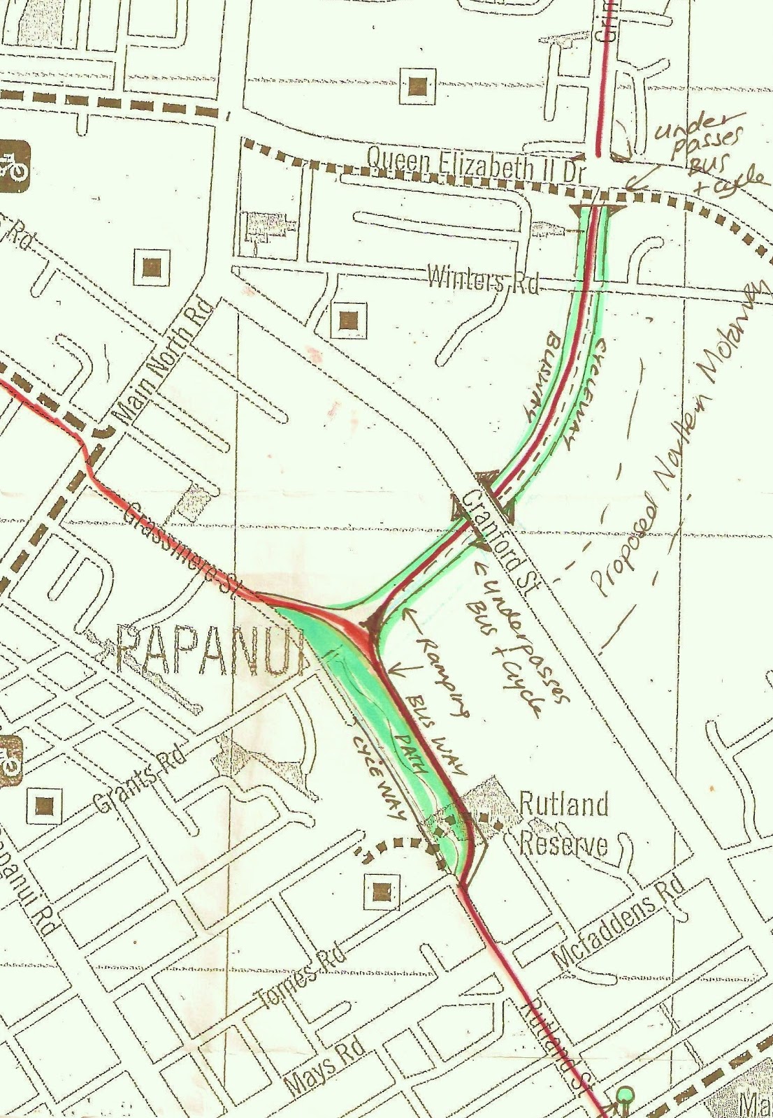
In the case of Grimseys Road/Redwood area (and soon Highfield area?) I have long advocated that the city build a simple bus/cycle/pedestrian subway under QEII drive, allowing a busway corridor to continue on another bus underpass/or bus only over-bridge bridge across Cranford Street, skirt the ponding area then down the alignment of Rutland Street, through a redesigned and greatly enhanced Massey Crescent area, and then via Caledonia Road, a direct north-city link that completely by-passes Northlands, Papanui Road, Merivale and Carlton Corner AND Cranford Street congestion. At the few intersections - Innes Road, Edgeware Road, Bealey Avenue bus priority signals would ensure very little time was ever spent at traffic lights.
This would give express buses a journey time of only 10 minute to city from Northlands, or of only 15 minutes from Belfast, using this non-stop transit-only access path into the city, for tens of thousands of northern residents (including those Rangiora and Kaiapoi).
It could probably be built for under $100 million, a small fraction compared to over $2 billion spent on bus,busway and railway infrastructure in Auckland and Wellington in the last decade. And this would amount would include significant landscaping and improvements - a new Rutland Park and Massey Crescent-Edgeware Pool "greenway" corridor and housing complex included.
I would imagine, seeing the way the world is going, that the buses - at least the full time high frequency branded service - would be fully electric or use hybrids running on electricity only through the built up areas and some possibly articulated buses. Adaptation to light rail might be considered in a decade or two once higher density housing along the route and the city ratepayer base has grown sufficiently, though clearly the corridor must be identified, created and protected now.
The map below ( a little outdated the Northern Motorway will now terminate at QEII Drive) conveys the importance of good land use in transport planning; it takes a largely undeveloped areas (one a ponding reserve) and creates a public transport control and device that almost entirely by-passes heavy congestion on Papanui Road and Cranford Street corridors, and at the Harewood Road and QEII Drive/Main North Road junction. Conventional services would continue to service these areas but the whole northern area could be quick quick no stress access to the city. What enormous appeal to live so close (travel time wise) to the heart of the new city yet enjoy suburban space and comforts.
A key factor for Highfield is the need to "drain" public transport catchment area at the Southern end (QEII Drive) so routes do not need to double back to the Prestons Road overbridge (hardly a direct express service in that case!) With a motorway between Redwood and Highfield this means Highfield buses could not conveniently use the subway suggested here. Either there would need to be bus subways from both areas OR a bus subway under the Northern Motorway near QEII Drive linking Highfield area to the feed-in point of the subway in the map.
Below is the current cycle subway below QEII Drive at the south end of Grimseys Road - a simple concrete trench with presumably the same level of overhead weight-bearing engineering as would be needed to create a comparable bus tunnel of similar dimensions, except of course a couple of metres deeper.

The city has already lost an important chance to link Birmingham Drive and Hillmorton Hospital to Lincoln Road and even Middleton Road, the University and Airport by not ensuring their was a simple bus only subway under the new motorway, will it continue to blow away more opportunities?
It is not rocket science that is needed...it is commitment to quality public transport and quality public transport access to northern suburbs tofro city that makes good bus services certain.
Obtaining clear run corridors that reduce journey time and give public transport an attractive advantage over cars is the internationally recognised as key to a competent mass transit strategy. But whilst Auckland and Wellington move into spending their third billion in public transport transport infrastructure Christchurch doesn't even have a serious mass transit infrastructure strategy!
As a result a 1950s style bus route is all that is "possible" !

I've always liked the thought of a busway through to Rutland street but what would be wrong with using the existing bus lanes on Main north rd (make them permanent and separated by narrowing the centre median)? Highfield, Belfast, Casebrook, Redwood Rangiora and Northwood buses could all access Northlands using this (maybe even put an underpass atQEii drive). These services could link at northlands to other buses (at a bus interchange at Northlands onto high quality frequent routes like orbiter to uni etc, comet to airport etc, buses down Pap Rd to schools). Then maybe utilise your fast bus way via Rutland / Springfield into town. This way we cater for links to all sorts of destinations not just suburbs to the city. An integrated bus network no less.
ReplyDeleteI really like to reading your post. Thank you so much for taking the time to share such a nice data.
Deletehong kong escort.
Hi Biani Vivace - Don't disagree that all of what you say is possible, for some trips or some services, but essentially I am preaching (allelujah!) the idea of keeping the central city accessible by public transport in less than 20 minutes from anywhere in Christchurch. Bus lanes will help moving around the inner suburbs, but the outer suburbs need what amount to semi exclusive "tubes" to shoot along unimpeded. For pure speed, smoothness, minimal stops and proper waiting facilities (level platforms and prepay to enter loading area) and being able to use articulated electric vehicles, I think the connection via Redwood straight across (under or over) Cranford Street, and down through Rutland can't be beat. With or without a rail connection, adding Rangiora, Kaiapoi, greatly expanded Belfast, Redwood and Highfield this offers fast city for 40-50,000 and growing. It is the class act we need.
ReplyDeleteas a 'northerner' who used the bus lanes pre-quake they were a great innovation and did speed the service. I think missing northlands and schools in pap road would be a mistake until you get a critical mass to express some services via the rutland option. Also your critique of the hub plan (3 July) seems to ignore the fact that the city centre is effectively a lot smaller now than it was. The CTB had a plan in the early 1980's to go to hubs, perhaps it is time public transport accepted that the central city is only one destination in our city(just like everyone else has)? Shoppers and employers have voted with their feet over the last 30 years and while the buses need to still service the CBD maybe its not the be all and end all? Look at the success of the orbiter - that type of frequency on major radials (without having to work out whether you need an 8 11 or 13) might work. Catch the bus to northlands and wait there for your bus to home rather than sit in the central exchange for 20 minutes (you could do the same at the palms, eastgate, riccarton as long as there is a decent exchange, and you will be exposing different people to the service than the ones who used it to get to town to work).
DeleteHi Biani (how great to get a genuinely interested reader prepared to argue the case. ps I am not being patronising, it takes me a lot of "psychic energy" to spend hours writing from the heart to thousands of faceless unresponsive people scared to even tick an I agree/disagree box!! But you do what you do in life, or you do not live life at all.
ReplyDeleteSo thank you.
The critical mass question...I am more inclined to the school of thought, "build it and they will come". Look at Auckland, run down dreary, minimal energy suburban rail system, carrying only 2.5 million passengers a year ...and now close to 11 million (if I remember rightly). That's a huge increase in people using public transport! Ok it has also been a huge cost but these infrastructure projects are measured across 25 years (and may go on generating benefits for 100 years). Also let's remember Canterbury generates GDP per capita very similar to Auckland, so essentially, we are donating millions a year to Auckland public transport, whilst failing to attract more than 5% of our own population into commuting by public transport.
Don't you think classy concrete smooth busways. lovely landscaped scenery, higher speeds (off roads)or even commuter rail here too, are fairly key to winning punters from car use?
I don't have any argument with a suburban hub plan, fantastic!! But what is planned is so amateurish, no obvious criteria or underlying system - why does Redwood get (via the tail end of the Comet) a 15 minute peak/30 minute service,and that a natural flow pattern (to the city); whilst large chunks of Bryndwr and Bishopdale get only an hourly service and any connections have to go "back" into Northlands? Why are there 15/30 minutes (even 10 minute = Orbiter) running through miles of open farmland country, with minimal population, - such as at Upper Styx, QEII Drive. Marshlands/Mairehau whilst more intensely settled areas get hourly or even no service? Ratepayers and taxpayers fund over half the costs so I think bus services should be modelled on consistent criteria, not a patchwork knee-jerk reaction. Yeah by all means only some of the "spokes" running to the city but they must be consistently and fairly (and logically) spread, and cross town links spliced into them precisely etc and all very easy to read and understand. I'll buy that. But not brutal, unsystematic, unfairly distributed networks, relying on connections with buses having no support infrastructure to run on time or connect, and proposals with large areas with no easy quick access to the big 4 - city [still & tomorrow] , airport, university and the indycorr - and at least 2 malls/service hubs.
I do agree shoppers have voted with their feet tho.and we do need a major reality adjustment - like a city bus system of 12 radials and 6 orbiters?
Cheers Dave, I must say that I think we may be hampered in Christchurch by trying to maintain buses on existing routes because that is where the authorities can justify that there are people who currently use them. Your comments about the orbiter reflect this - if there is a 10 minute orbiter along shirley road and hills road do we need a service in Emmett Street? Every bus journey starts with a walk, maybe its time to revisit some of the old routes and do it properly using the orbiter and major cross town routes as the basis. Thats why I like the concept of the new proposals -I think the earthquakes have given us the chance to be more radical
ReplyDeletemy view -Plan change is not expected to generate any adverse effects on the transport system.
ReplyDeleteconcretor highfields
Hi, Thanks for the sharing.
ReplyDeleteCar service highfields qld
Hi thanks for sharing the nice information.
ReplyDeleteYour blog provide a important info for transporting etc. I would like to offer a best vehicle repairs highfields qld at a very cheap prices.......
ReplyDeleteHere's how to cut your electric bill up to 75%:
ReplyDeleteWant to know how to easily produce all of the green energy you could ever want right at home?
And you’ll be able to make your home totally immune from power outages, blackouts, and energy grid failures…
so even if everyone else in your area (or even the whole country) loses power - you won’t.
HERE'S HOW: DIY HOME ENERGY