The Edge where the world divides? Are we going to make genuinely effective modern public transport or just talk the talk?

This suggests any rational analysis of cost-benefit bus rapid transport would have to say that the least disruptive, by far the most direct, logical, and multi-beneficial northern rapid transit outlet tofro the city centre, that does not involves scores of house demolitions would need utilise the Rutland Street Corridor. This can be linked to Edgeware in the south by an enormously enhanced green housing, busway, bikeway etc redevelopment, running through to Edgeware Rd, and in the north under (or over) Cranford Street and QEII drive to Redwood, Highfield, Prestons and areas north beyond) - giving buses a direct bypass of all the heavy road use corridors. A huge boost to the central city rebuilt - Belfast to city in about 12 minutes, irrespective of how busy the roads! A bus system actually competitive with car use in many situations !!
Going Fast - A busway lost ?
(reprinted from 18 April 2010)
I have been campaigning since 2002 to have local public transport planners and civic authorities investigate the potential of corridor through St Albans towards Northlands for a busway alignment and direct cycleway to city. Originally I sent letters to the newspaper, in 2005 I sent a beautifully prepared simple clear document with maps to Garry Moore (then Mayor) and to ECan our public transport parent organisation. In 2007 I circulated an extended version of the same scheme - now with a busway corridor right up to Belfast - to about 35 candidates to the local body elections. One or two were polite enough to say "How nice dear". In that time Ecan investigated rail twice (ridiculously expensive and unsuited)**.
Never once have I heard the slightest squeak from any corner that busways were being seriously looked at in Christchurch.
Obviously once built this corridor would be there for all time, so to speak, could not be built out however big or high rise the city became. It seems a good investment before the options are built out, for instance larger modern flats built right in its flowpath, costing a fortune to uproot. With two Council housing complexes and the Council owned Edgeware Pool site in the most obvious pathway options for relatively cheap redevelopment of the partly run down area were manifold.
Amazingly what could be an 8 minute journey by bus direct from the central city to Northlands, some of it through attractively landscaped green bus (and cycleway) only boulevards, not only bypasses all the heavy congestion on Papanui Road or Cranford Street but can be achieved with minimal social impact, expense in building or operation.
This busway centred route network could be operated by a branded service, every 15 minutes, supplemented by key stop only express buses coming from Styx,Belfast, Redwood, Kaiapoi, Rangiora etc. in morning and evening weekday peak hours. Other services would continue to travel via Northlands and Merivale of course, for those travelling to those areas. If it ever became viable to operate light rail then this corridor would already be built - and indeed could be built precisely to allow for that future option. (It is almost an industry standard now to build a busway as a precursor to light rail in overseas cities). Never once have I heard the slightest squeak from any corner that busways were being seriously looked at in Christchurch.
During these eight years Auckland received $200 million from the Government to build their Northern busway; and then a further $20 million towards their $46 million Central Connector busway. (and zillions more for rail). During that period that period cities all over the world from the huge (Beijing building 20 busways) and sprawling (Johannesburg building 270km of busway) to those small and closer to Christchurch in size and demographic patterns - such as Halifax, Ottawa,Winnipeg, Gatineau, Calgary etc in Canada - were investigating and building busways, typically a mixture of on-street bus lanes and bus-only separate corridors, bus-only shoulder lanes, underpasses etc.
One of our nearest neighbours, Brisbane has built the most sophisticated busway in the world, in one section buses travelling to a bus station at third storey height and other points into underground stations and trenches that completely by-pass congestion. The Gold Coast's planned light rail corridor - 17 km and $1.8 billion (and rising) is estimated to be accessible to 20% of the population. By contrast the Brisbane busway [also of course very expensive!] runs for several hundred kilometres of route - by virtue of the fact that 117 different bus routes feed into and get the benefits of the segregated corridor system. A system that benefits everyone. Something, obviously a bit more modest in size and engineering could obviously be looked at for our city. Never once have I heard the slightest squeak from any corner that busways were being seriously looked at in Christchurch.
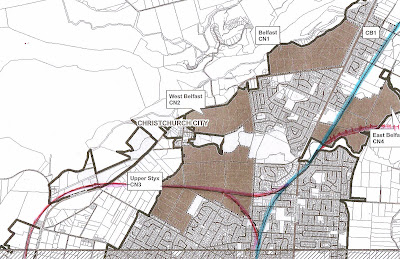
This week I posted off a submission to the Metro Strategy 2010 Review. Above is the alignment of the Northern busway I see as possible. Given express buses would not stop between the Supa Centa and Bealey Avenue (or only stop at key stops) and the actual distances are not huge, it would take around 10 minutes Belfast to the city by bus in peak hours! Not only a huge saving in commuter hours but also of course, greater economy in bus use and driver hours per kilometre.
The submission is a parting shot really because the Northern motorway coming down past the east side of Redwood is already planned and has as far as I know, no provision for a bus only lane to cut down the side and then through onto Grimseys Road. There is a cycle subway under QEII Drive at the bottom of Grimseys Road but I have never heard of any bus underpass planned. The area east and immediately north of Paparoa Street School and the Rutland Street Reserve, farmland and floodplain, which could be reconstituted into an attractive park, cycleway and skirting the edges on a fenced embankment, a busway corridor, has been subdivided and presumably sold off.
The Edgeware Pool site - which coupled with a couple of older single storey Council Housing complexes - gave great potential for an exciting redevelopment of the area and an Edgeware bus station has been sold off. Ironically a far better, combination neighbourhood integrated recreation centre including pool and slightly re-sited tennis club could have really empowered a future high density neighbourhood AND made busway possible.
We have not only missed the bus, or tomorrow's light rail corridor - as a city we are too stupid to even realise it!
Somewhere in between city hall's preoccupation with light rail fantasies and building heritage tramways and Ecan's narrow vision of a good conventional bus system, a gift handed to the city on a plate got thrown out, a potential to lever up tens of millions in Government funding was ignored, a great public transport makeover of a partly derelict area was never seen, great opportunities got washed away. Without a squeak.
This illustration below comes from a later blog posting I believe now it would be more logical to use earthquake rubble to build a beautifully graduated busway ramp, not only behind the park as shown here, but up and over Cranford Street rather than under

In this scenario - The current Rutland Park (which runs in a rectangle west-east) is converted to an elongated north-south (approximately) park with cycleways and stream and walkways and a inconspicuously fenced on busway on its own embankment; one arm to Northlands and Sawyers Arms Road - the other running over or under Cranford Street and ditto QEII to serve Redwood, Highfield Prestons, Belfast and the northern rural towns with a very quick journey to cuty centre and beyond. Needless to say any land close could be designated higher density (rather than just congested key points like Papanui) including a central retirement village friendly zone around Rutland Street
A customised Google map of the same project
** Since 2010 I believe rail would be viable but only in a comprehensive "figure eight with spurs" network linked to extensive off road cycleways. See multiple postings

Its good to know that there is a cycle subway under QEII Drive at the bottom of Grimseys Road but I have never heard of any bus underpass planned.
ReplyDeleteThanks Redbus - you hit the nail on the head there!
ReplyDelete