City must plan rapid transit corridors

Looking good in Hei Hei? Ooops, forgot to plan ahead!! ** see below
"...In past postings I have identified other potential corridors being lost here and there. I think there is some bloody good ideas amongst them but the key point is not whether this or that corridor is the right one - the key point is the city has not identified any rapid transit corridors, so is unable to protect them. "
I have read the feature article in the weekend paper, entitled "Changing Tracks", (The Press 31 July 2010) about public transport issues in the up coming local body elections. I have read - in a box adjoining the same article - the poorly informed descriptions of Bus Rapid Transit BRT by Press feature writer John McCrone (or perhaps some other journalist). I have read today's perspective piece in The Press (p17) by [unelected and imposed] Ecan Commissioner for Public Tranport matters Rex Williams about the future Metro strategy.
Sure, I appreciate that press reports, quotings of politicians and that very summarised descriptions of plans can, by their nature, be very distorted and miss things. But even so, what jumps out at me is that NOT ONE of these politicans or planners identify what I would personally see as the key task for Christchurch and the anchor point around which every other strategy is pivoted.
This primary need is the need to identify where people live and work or will do so in coming years and map out specific rapid transit corridors - wherever possible segregated corridors, not vulnerable or impeded by other traffic.
This was the basis of Aucklands public transport strategy, established back in about 1998 that decided on four rail corridors and two busways; it is the essence of Wellington's development (the upgrading and extension of existing rail rapid transit corridors); it is the cornerstone of public transport strategies in many cities in Canada, similar to NZ. Sensibly so; because winning peak hour commuters is a key to cutting green houses gases, is the journey easiest to replicate by public transport in many cases, is the peak hour factor against which all roading expansion is measured.
Reading comments in the Saturday Press article by Christchurch Mayoral candidates Bob Parker, Jim Anderton and Jo Kane (the latter standing for Waimakariri Mayor) there is so much fluffiness in their thinking it appalls me. This is particularly so for Bus Rapid Transit (BRT), all typically confusing the concept with one of its (lesser) component elements, non-segregated on-street bus lanes. We will not be building "railway station" type bus stops, room for multiple articulated length buses, trenches and underpasses or computerised clear run systems if our starting premise is to merely run buses (or trams for that matter) on conventional streets and painted roads. Nor will be creating the rapid transit systems that make it remotely possible to approach Wellington levels of patronage, as put forward by Rex Williams, without a specific rapid transit strategy.
The remarkable number of motorists fined in Auckland for parking or driving in bus lanes (where bus lanes have been operating over a decade) reaffirms a world wide pattern. The reason completely segregated corridors are replacing on street painted bus lanes is that painted only bus lanes are constantly being compromised and impeded by opportunist motorists. They offer a far from ideal form of rapid transit in themselves. This is quite apart from the fact services from outer areas can save much time by cutting across suburbs, leaving conventional bus services on arterial roads to access en route employment zones. Even conventional bus lanes in Paris (after Hong Kong, one of the world's densest cities) are segregated by curbing and islands.
Light rail has suceeded to the extent that it does amongst other reasons because systems in Europe have high levels of tramline segregation - in France 80% of light rail is off-road; Germany taking advantage of war damage, rebuilt most it tramway system post World War II on their own segregated right of way. Ditto most of the new systems being built in the USA.
Likewise commuter rail - apart from this train through the streets of Michigan City [see unusual photo above, and info link below] it is rare to run trains down the centre of streets!! Therefore they need corridors - and that doesn't just mean using a existing single track - transport planners "we're protecting the corridor for future commuter rail" (yeah right!). It means clearly identifying future commuter rail needs - where tracks would run; where they would need to be doubled or tripled; where stations or park and ride lots would go, how they would interact with existing and new residential and industrial areas.
My general impression from years of internet transit system hopping (and the occasional book or transport magazine) is that it is corridor that is primary - not the mode. Equally lane capacity is more relevant than vehicle capacity. Common sense would suggest if a five storey building is built on a corner then it would add phenomenally to the costs, if a decade hence it lies right in the path of a rail, light rail or busway corridor. Conversely if it is defined now where a suburban railway station will be built - perhaps 20 years hence - then the city can buy that land and build removable housing for a retirement village or rental residents designed to last two decades, simultaneously blocking any other, inappropriate, or difficult to remove development. An industrial subdivision can have a big container yard - for years - just where tomorrow's suburban station will stand. To protect our future and our prosperity, identifying rapid transit corridors is a primary consideration.
This is why we need a vision and a gameplan. Most of the mode choices - bus, BRT, light rail, rail etc - would flow out of that by natural calculation of costs and cost/benefit ratios (or at least place planning on some intelligent level greater than pin-in-the-map and fashionable preference methods). Despite public opinion transit is a science of sorts with clear methods and criteria for determining viability.
Most of this advance planning does not cost a huge amount of money, less than a million or something - it just takes committment planning and vision, work now but for the future. It might be ten or twenty years before a project is implemented but where it a line or busway will go has been safeguarded, for example by only allowing removable buildings or car parks or whatever on the required site. As things stand potential corridors are being built out by the month. As I challenged in a spoken (passionately, of course!) submission made to an ECan strategic planning review some years ago, chaired by Jo Kane, how can the stated policy of protecting corridors be anything but nonsense if precise corridors have not been identified?!!
EXAMPLE I read some time ago application for a five story building to be built on the corner of Moorhouse Avenue and Hagley Avenue (facing Hagley Park). This has been designed with a relatively small tar-sealed car park at the rear. I have no idea whether this project is still going ahead or not but it struck me as madness - why doesn't the city buy four metres off the Hagley Avenue frontage (= 3 or 4 less car parks out the back? ) so that an extra turning lane can be built for cars turning left into Moorhouse Avenue or running straight across to Grove Street and the new Hazledean Office Park. Why?? Because then we have room on Hagley Avenue for a full time extra bus only - or tram only - lane running straight ahead, securing for all time the ability of public transport vehicles to get to the front of the queue (and get queue jumper lights - 10 seconds head start) on entering what is one of the four busiest arterials roads in Christchurch. Even if the city had to negotiate funding an extra parking floor - it could be a far more effective rapid transit option than alternate routes forced by failure to plan in advance.
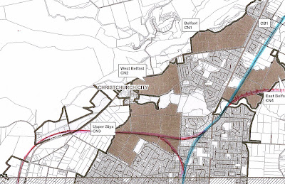
Or a new industrial park now planned for Islington - has anyone assessed in what circumstances it would be valuable and necessary to implement a rail corridor from Islington to Styx Mill via the airport? Has anyone asked would this industrial estate block or complement that line? How can they -as a city we have no rapid transit plane to measure or monitor against. We only have to look at the bizarre castration of the present city railway station, where it is not possible to run straight from the north then left/east towards the city, to know that lack of long term strategy has cost us and will cost us money and opportunity.
At Annex Road a brilliant chance to cut a public transport straight up from the south-west to northwest, running under the new (and old) motorway and railway yards [all for about a quarter the $92 million cost of extending commuter rail to Waikanae, total population 38,000] and completely bypassing all other congested roads is being lost because no rapid transit identified it three years ago. No strategy; no projects; no funding.
At Grassmere Street land that could help connect Northlands to the city in ten minutes straight is being sold as sub-division. This a connection I suggested to then Mayor Garry Moore and Ecan in 2005 in a five page document of texts and maps. It could save thousands of hours per year in bus (or maybe one day light rail) commuting time from the northern suburbs and Rangiora etc. Done right it could offer an attractive landscaped busway, cycle and pedestrian boulevard and extended park right up the middle of one of Christchurch's denser suburbs.
There is a curious paradox in Christchurch public transport - we have a good across the board (all hours, off peak system etc) but in terms of real grunt , peak hour commutes our system is going nowhere.
For almost a decade Christchurch has built a betterthan average bus system but failed to win a significant portion of peak hour punters because it is going nowhere - literally as well as figuratively - because this city has not identified the corridors it needs to build mass transit. That to me is the core task.
** The South Shore Line from Chicago which passes through [and I don't use the expression "through" lightly!] Michigan City, Indiana. It is one of the last of the old inter-urban services, many of of them more like large trams, which once operated as regional rail services from cities around the USA . The service started in 1901 when it was still quite normal, even in New York, to have full size locomotives shunting in city streets (Photo per L Hoon - Wikipedia Commons).

Comments
Post a Comment